Geography Quick Reference: A Free Printable Poster for Grades 4–7
A free four-page geography printable for kids: map skills, South Africa's provinces and capitals, the water cycle, and key people-and-planet words. Pin it up as a poster or cut it into study cards.
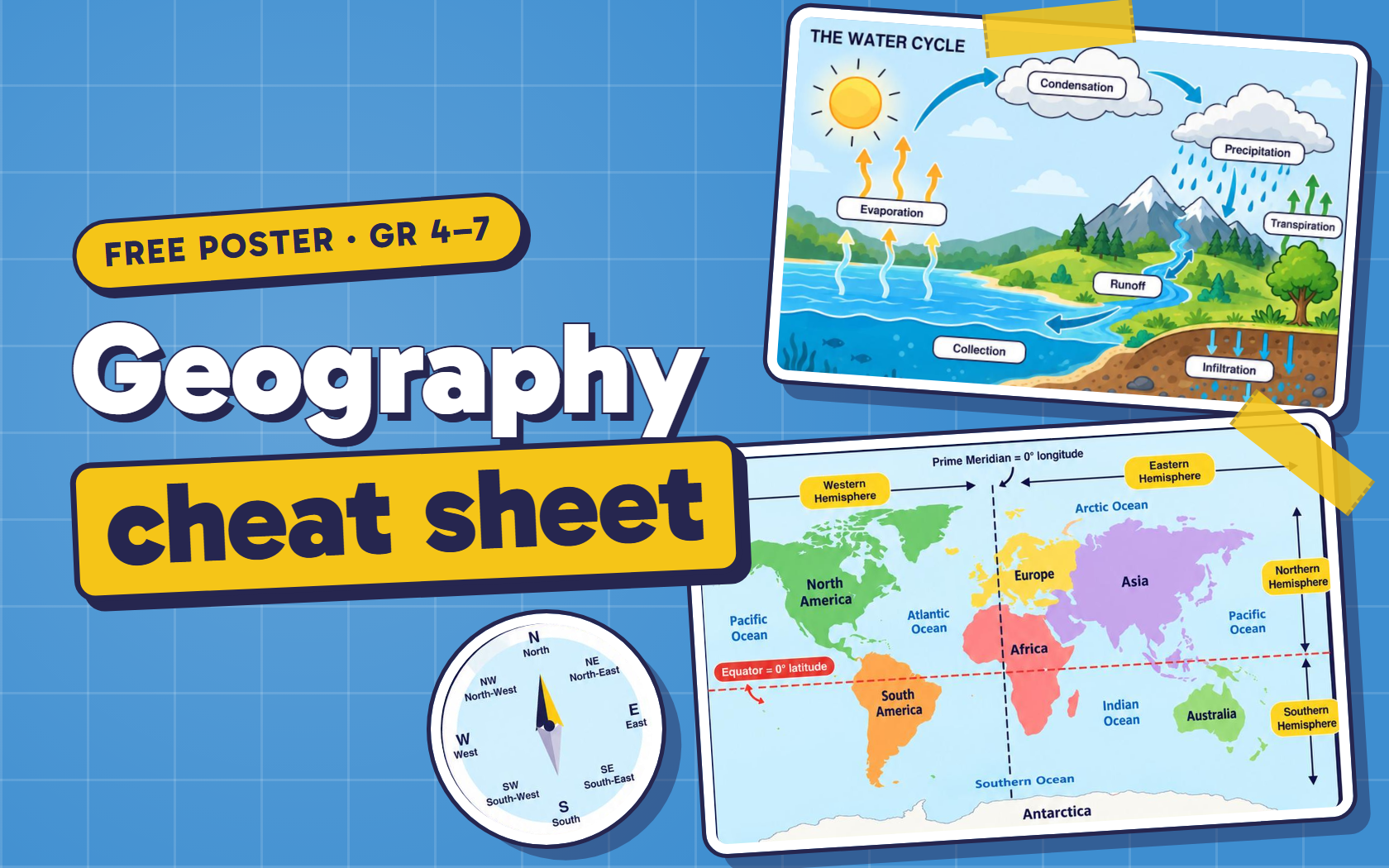
The first year a child has Geography as its own subject, it can feel like a flood of new words: hemisphere, scale, tributary, precipitation, density. Then the next year comes, and the same words come back. And the year after that.
That’s not a flaw in the curriculum. It’s how geography is built. The ideas a child meets in Grade 4 are the foundation for every year after. A compass rose in Grade 4 becomes grid references in Grade 5 and latitude and longitude after that. The water cycle turns into weather, then climate, then floods and droughts.
So rather than relearn those basics from a blank page every year, I made one place to keep them. Four pages, with the ideas that keep coming back, laid out so a child can find the fact they need in a few seconds.
Get this for free
Sign in with Google, Facebook or email to download.
Your download is ready
Download ⬇Why a picture beats repetition
Kids usually learn geography terms the same way they learn spelling words: read the definition, cover it, say it again. It works for the test on Friday, and by the next term most of it is gone.
What lasts longer is seeing the idea. A child who has looked at a dashed red line across a world map a hundred times doesn’t need to memorise that the equator is 0° latitude. They can picture where it runs, which continents it cuts through, and which side South Africa is on. That’s a picture they can call up in an exam, a conversation or the car.
That’s why this is a poster and not a worksheet. It works best when it’s somewhere they look every day without trying: next to the desk, on the inside of a cupboard door, above the bed. Repetition gets the word in. Seeing it every day ties it to a picture, and the picture is what they remember.
What’s on each page
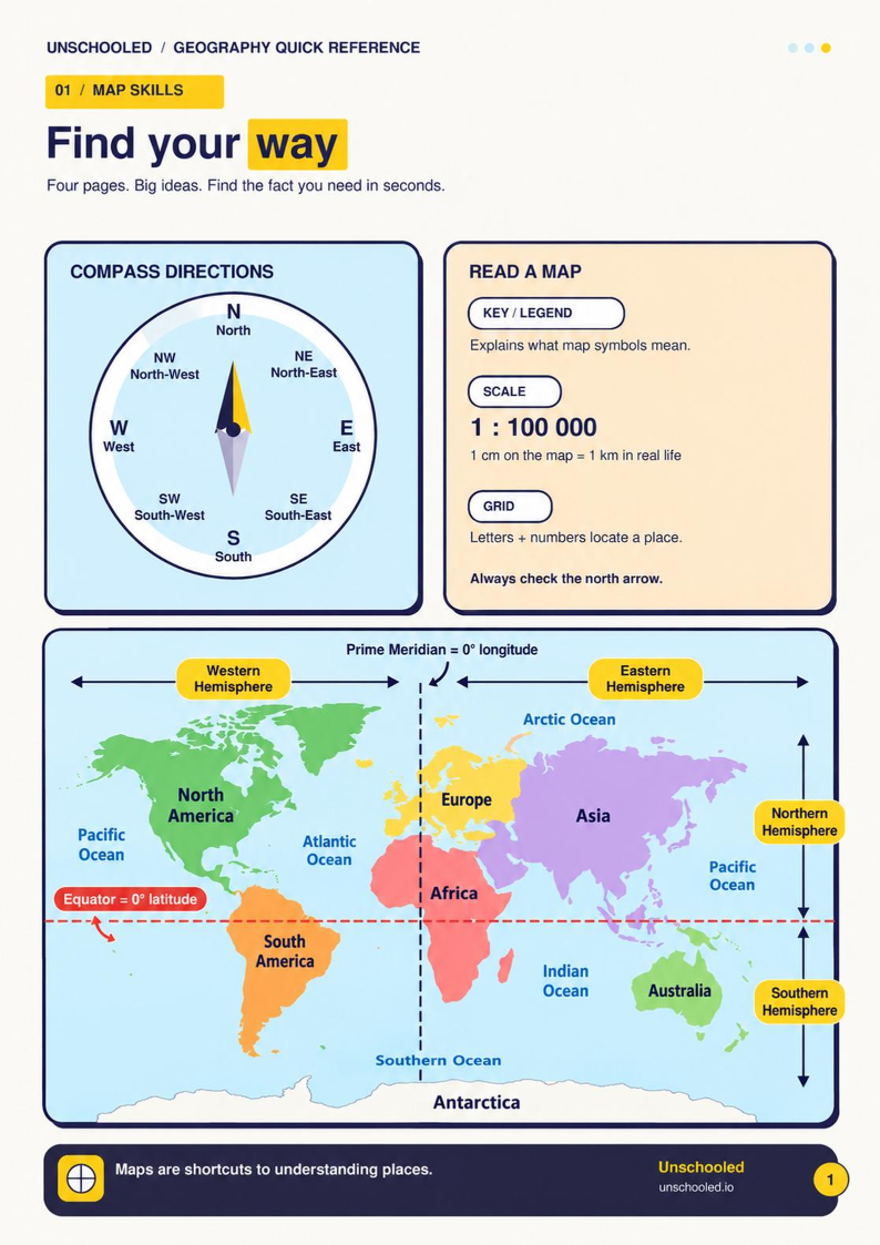
Page 1 — Map skills: Find your way
- Compass directions. All eight points, N to NW, with the full names underneath. Kids who are shaky on directions usually mix up the in-between points, so those are spelled out.
- Reading a map. The three tools every map gives you: the key or legend (what the symbols mean), the scale and the grid. The scale example is 1 : 100 000, which means 1 cm on the map is 100 000 cm in real life, and that’s exactly 1 km. It’s a good one to work through together, because the jump from centimetres to kilometres is where most kids get stuck.
- The world map. The seven continents, the five oceans, the equator (0° latitude) and the prime meridian (0° longitude), and the four hemispheres they create. Ask your child to find South Africa and say which two hemispheres it’s in. (Southern and Eastern.)
Page 2 — South Africa: Know your country
- The nine provinces and their capitals, from Polokwane in Limpopo down to Cape Town in the Western Cape, with the neighbouring countries and both oceans around the edge.
- South Africa’s three capital cities. This one confuses adults too. Pretoria is the seat of government (executive), Cape Town is where Parliament sits (legislative), and Bloemfontein has traditionally been the judicial capital.
- Land and water words. Mountain and valley, river and tributary, plateau and plain, each drawn as a simple shape so the word comes with a picture.
Page 3 — The natural world: Follow the water
- The water cycle. Evaporation, condensation, precipitation, runoff and collection, plus the two parts kids often miss: infiltration (water soaking into the ground) and transpiration (plants releasing water into the air). It’s drawn as a loop because it is one. There’s no first step, and kids find that surprisingly satisfying once it clicks.
- Weather vs climate. Weather is today and this week. Climate is the usual pattern over many years. There are also the units that go with them: °C for temperature, mm for rainfall, direction and speed for wind.
- Fresh water. Where we find it (rivers, lakes, dams, underground) and three simple ways to protect it. In a water-scarce country like ours, this one matters outside the classroom too.
Page 4 — People & planet: See the connections
Six short pairs of terms that come up again and again in the senior grades:
- Settlements: rural and urban
- Farming: crops and livestock
- Trade: import and export
- Resources: renewable and non-renewable
- Population: population and density
- Natural hazards: floods, earthquakes and volcanoes, and how to reduce the risk
Across the bottom is the idea that holds the page together: conservation, which means looking after resources and living things so they’re still there in the future.
Which grades it’s for
It’s made with the South African CAPS Social Sciences (Geography) content for Grades 4 to 7 in mind, but almost everything on it is universal. Compass points, continents and the water cycle are the same wherever you live.
Roughly how it lines up:
- Grade 4: map skills, compass directions, rural and urban settlements, food and farming, water.
- Grade 5: grid references and scale, South Africa’s provinces and landforms, weather and climate.
- Grade 6: latitude and longitude, trade, population.
- Grade 7: natural hazards, resources and conservation, plus all the map work again in more detail.
A Grade 4 child will grow into the later pages. A Grade 7 child can use it to revise everything they’ve already covered, and it’s handy before exams.
Three ways to use it
1. As a poster. Print all four pages and put them up side by side where your child spends time. The pages are A4 and can be enlarged to A3 if you’d like it bigger on the wall. Most home printers have a “fit to page” option for this, or any print shop can do it.
2. As study cards. Every topic sits in its own bordered box, so the pages cut cleanly into about fifteen cards: the compass, the map tools, the world map, the province map, and so on. Cut along the box edges. Glue them onto card if you want them to last, then punch a hole in the corner and keep them on a ring. Kids can pull out the “water cycle” card when that’s the week’s topic.
3. In their books. A single card glued inside the front cover of a Geography workbook means the answer is already there when they need it. The compass and map-tools cards are the best ones to start with, because they’re used in nearly every map exercise.
Make it stick
The poster does more if you use it now and then instead of only hanging it up:
- Point and ask. “We’re driving to Bloemfontein. Which province is that, and which direction are we going?” Thirty seconds, no worksheet.
- Watch the weather report together. Point out when they say °C, mm or wind direction. Every unit on page 3 shows up in an ordinary forecast.
- Spot the water cycle. Steam off a kettle, a cold glass that “sweats”, puddles that are gone by the afternoon. Each one is a step on page 3.
- Let them teach it. Ask your child to explain one card to a younger sibling or a grandparent. If they can explain it, they know it.
Where to go next
If the world map gets them curious about the people living on it, try How Many People Are on Earth?, a live interactive map where kids hover any country to see its population.
For the story behind the provinces on page 2, the History of South Africa timeline walks through how the country got its shape.
Geography isn’t a list of places to memorise. It explains why people live where they do, why the rain falls where it falls, and why the shop sells what it sells. A child who can read a map can understand more of the world around them.
Get this for free
Sign in with Google, Facebook or email to download.
Have your say
Sign up or log in to join the conversation — share a tip, ask a question, or say what worked for you.